|
|
|
|
| World War II |
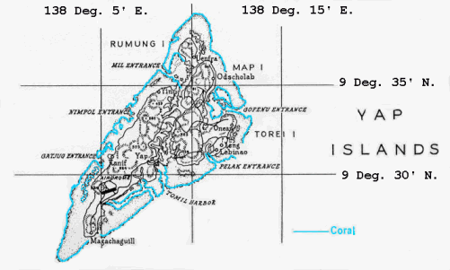
| and 1944 map of Yap. |
| Tour of Duty at Yap (with Map) |
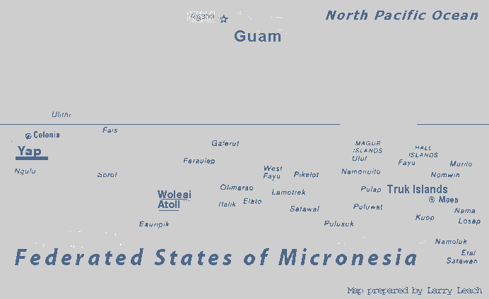
The Yap Islands lie about 520 miles SouthWest of Guam. There are four main islands with several small outlying islands and atolls. Yap is one of the largest island groups of the Federated States of Micronesia. (The above map does not show all of the Federated States of Micronesia.)
 The Federated States of Micronesia are south of Guam and north of the Equator
and they include most of the Caroline Islands. They span 1800 miles east to
west (135 to 166 deg E. Longitude). Their independence was gained on Nov. 3, 1983.
It has the states of Yap, Pohnpei, Kosrae and Truk.
For a history of the Federated States of Micronesia go to
Link: History of the FSM.
The Federated States of Micronesia are south of Guam and north of the Equator
and they include most of the Caroline Islands. They span 1800 miles east to
west (135 to 166 deg E. Longitude). Their independence was gained on Nov. 3, 1983.
It has the states of Yap, Pohnpei, Kosrae and Truk.
For a history of the Federated States of Micronesia go to
Link: History of the FSM.Yap is probably best known for its large round circular stone money. It is
becoming well-known to scuba divers as a great place to see giant manta rays.
For information about Yap go to Link: Information about Yap.
Tour of Duty at Yap (1965).
Go to Top of PageThe duty at Yap was much different than at Woleai. The tracking station
was at a US Coast Guard LORAN transmitting station on Gagil-Tomil Island.
Our quarters were here and the rooms were quite nice. The food was also
pretty good. I remember that I could have steak with my breakfast if I
wanted to. However we were several miles from the town of Colonia and
the mail service was not always regular, so we still felt sort of isolated.
The Yap Islands were much bigger than Woleai and we needed vehicles to get around.
|
|
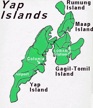
General map of Yap showing the locations of Colonia, the US Coast Guard LORAN Station and the Yap Airport. The Coast Guard LORAN Station is now a radio station. (Map provided by Larry Leach.) |
|
|
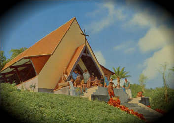
First Evangelical Church (from a postcard picture) |
|
On the main island, the town of Colonia was quite interesting. Here there were stores, churches and other facilities. I met some Americans and Australians that were there for different reasons. I remember that there was a Catholic mission and some Americans were serving there. I went to a Protestant Church that was pastored by a most unusual man. His last name was Kalau and he had been a German soldier who fought on the Russian Front in World War II. He could give a powerful testimony about how his life had been changed. He also pastored a church at Palau, another island away from Yap. For archival pictures of the church at Yap and Rev Kalau, go to Link: Pacific Archives (go to Reel 2648). Also, for some history of Rev. Kalau's ministry to the islands, go to Link: Pacific Missionary Aviation. |
On Yap, I noticed that little Japanese Toyota and Datsun pickup trucks
and cars were very popular. I wasn't used to seeing foreign cars. (OK,
maybe they were in California at the time, but strange to a boy from Indiana.)
Even though wreckage of World War II was still evident on the island,
it was also plain that Japan was making its economic comeback.
World War II
Top of Page Next PageMuch of Micronesia had been in Japanese control since World War I. Prior to World War II it was built up like many other islands they controlled and become strategically important. Yap was a fairly large island group and over 10,000 troops were stationed here at peak strength. There was an important air base here. Like Woleai, Yap was attacked many times in 1944 and also into early 1945. The US Military initially planned to invade Yap but this plan was later cancelled. Yap was neutralized like Woleai. The Japanese Garrison on Yap officially surrendered on September 2, 1945.
|
| 1944 Map of Yap Islands (with some enhancements). Courtesy of the National Library of Australia. |
(Go to Main Pacific Page) (Go to Next Page)